

Carrowreagh : Barrow
Visit Notes
Sunday, 25th April 2010
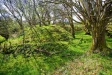
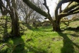
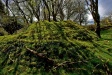
I often say that County Laois does not have many monuments, but all is forgiven! This barrow is among the best examples in Ireland. What a beauty!
The mound is over 3m tall and the surrounding ditch is over 2m wide and 1m deep. The overall diameter is is around 20m. The location is on a wide shelf on the southern foothills of the Slieve Bloom Mountains would offer fine views to the south, but the views from the barrow itself are minimal due to the fine collection of gnarled old trees that grow around and on the barrow.
The is something almost Tolkeinesque about this barrow. I visited on a fine and sunny day, but on a damp, bleak day with a bit of mist around and this would be a gloomy, etherial site.
Getting to the site is a bit of a trek, but it's worth all the effort. You can drive most of the way up a farm track (through two gates) if you want to and walk the last 150m or so. Look for the signpost to the ring fort at the bottom of the lane.
Click Thumbnail to View Full Size Image
________


Like this monument
Marked Sites
3D Animations
Click Thumbnail to View Full Size Image
 _
_ _
_Random Gazetteer
A Selection of Other Barrows
About Coordinates Displayed
|
This is an explanation of (and a bit of a disclaimer for) the coordinates I provide. Where a GPS figure is given this is the master for all other coordinates. According to my Garmin these are quite accurate. Where there is no GPS figure the 6 figure grid reference is master for the others. This may not be very accurate as it could have come from the OS maps and could have been read by eye. Consequently, all other cordinates are going to have inaccuracies. The calculation of Longitude and Latitude uses an algorithm that is not 100% accurate. The long/lat figures are used as a basis for calculating the UTM & ITM coordinates. Consequently, UTM & ITM coordinates are slightly out. UTM is a global coordinate system - Universal Transverse Mercator - that is at the core of the GPS system. ITM is the new coordinate system - Irish Transverse Mercator - that is more accurate and more GPS friendly than the Irish Grid Reference system. This will be used on the next generation of Irish OS maps. |


Page loaded from cache: (Generation time: January 17 2020 21:34:36.)