


Knocklane : Cist
This is a subsite of:
Visit Notes
Monday, 25th April 2011
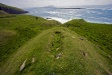
This cost is set into the top edge of the promontory fort defenses overlooking the entrance to the inner area. It is about 3m long and 50cm wide.
Click Thumbnail to View Full Size Image
_
Like this monument
Marked Sites
Random Gazetteer
A Selection of Other Cists
About Coordinates Displayed
|
This is an explanation of (and a bit of a disclaimer for) the coordinates I provide. Where a GPS figure is given this is the master for all other coordinates. According to my Garmin these are quite accurate. Where there is no GPS figure the 6 figure grid reference is master for the others. This may not be very accurate as it could have come from the OS maps and could have been read by eye. Consequently, all other cordinates are going to have inaccuracies. The calculation of Longitude and Latitude uses an algorithm that is not 100% accurate. The long/lat figures are used as a basis for calculating the UTM & ITM coordinates. Consequently, UTM & ITM coordinates are slightly out. UTM is a global coordinate system - Universal Transverse Mercator - that is at the core of the GPS system. ITM is the new coordinate system - Irish Transverse Mercator - that is more accurate and more GPS friendly than the Irish Grid Reference system. This will be used on the next generation of Irish OS maps. |


Page loaded from cache: (Generation time: January 18 2020 01:11:03.)