


Knocklane : Promontory Fort
This site has subsites
| Knocklane - Cist |
Visit Notes
Monday, 25th April 2011
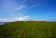
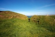
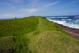
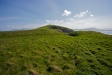
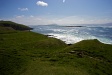
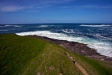
I first saw this site from the sea on the way to Inishmurray (County Sligo). From the water you can fully see the huge scale of the earthworks protecting this spit of land.
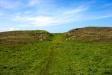
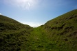
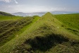
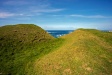
The first bank is about 3m high as you approach and this droops into a ditch some 4m deep. Beyond this there is another bank at least 5m high. Leading between the two there is a causeway that breaks the two banks in a straight line. The short distance between then does not allow for a staggered entrance.
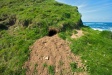
Set into the top of the inner bank, just above the entrance there is a long cist.
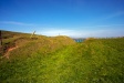
The seaward edges do not have high banks to protect them, but below are jagged rocks and attempting to come ashore this way would be very dangerous.
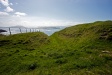
It was on the inner bank we found an otter skull, near to what looks like an otter's holt (do sea otter have holts too?)
Click Thumbnail to View Full Size Image
_______________


Like this monument
Marked Sites
Random Gazetteer
A Selection of Other Promontory Forts
About Coordinates Displayed
|
This is an explanation of (and a bit of a disclaimer for) the coordinates I provide. Where a GPS figure is given this is the master for all other coordinates. According to my Garmin these are quite accurate. Where there is no GPS figure the 6 figure grid reference is master for the others. This may not be very accurate as it could have come from the OS maps and could have been read by eye. Consequently, all other cordinates are going to have inaccuracies. The calculation of Longitude and Latitude uses an algorithm that is not 100% accurate. The long/lat figures are used as a basis for calculating the UTM & ITM coordinates. Consequently, UTM & ITM coordinates are slightly out. UTM is a global coordinate system - Universal Transverse Mercator - that is at the core of the GPS system. ITM is the new coordinate system - Irish Transverse Mercator - that is more accurate and more GPS friendly than the Irish Grid Reference system. This will be used on the next generation of Irish OS maps. |


Page loaded from cache: (Generation time: January 17 2020 20:50:21.)