


Calliagh : Wedge Tomb
Visit Notes
Sunday, 7th March 2010
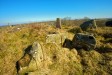
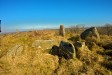
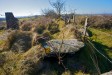
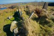
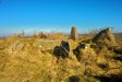
It is wonderful when you come across a really good monument and this certainly falls into that category. The location is just wonderful, on the top of a high drumlin overlooking fields and two small loughs.
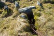
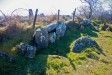
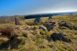
The state of preservation is very good, although several roofstones have been removed. The cairn remains to the height of the gallery walls and is covered in tussocks of long grass. The gallery is about 5m long with around 2m of its length roofless. At the front of the gallery there is an ante-chamber that is separated from the gallery by a septal slab . After trampling down the brambles inside the gallery I could feel several stones underfoot, which may be sill stones or just rubble from the cairn.
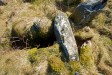
To either side of the ante-chamber you can see the double walling. Inside the ante-chamber area there is a displaced stone leaning against one of the walls. It is too small to have been a roofstone, so it could have been an orthostat forming a split portico.
To the front and side of the mound, which is nearly 20m long and over 10m wide, there are two large upright stones (2m high). I think there are re-erected roofstones, but they could be original features.
A fence runs across the back edge of the monument and exposed a series of upright flags, which could be part of the original kerb.
In the next field, hiding in the permanent shadow of a hedgerow we found some snow. I doubt it'll be there for much longer, but it gave us another memory to take away with us: snow in March!
Click Thumbnail to View Full Size Image
_____________

Like this monument
Marked Sites
3D Anaglyph Images
Click Thumbnail to View Full Size Image
 _
_ _
_3D Animations
Click Thumbnail to View Full Size Image
 _
_Random Gazetteer
A Selection of Other Wedge Tombs
About Coordinates Displayed
|
This is an explanation of (and a bit of a disclaimer for) the coordinates I provide. Where a GPS figure is given this is the master for all other coordinates. According to my Garmin these are quite accurate. Where there is no GPS figure the 6 figure grid reference is master for the others. This may not be very accurate as it could have come from the OS maps and could have been read by eye. Consequently, all other cordinates are going to have inaccuracies. The calculation of Longitude and Latitude uses an algorithm that is not 100% accurate. The long/lat figures are used as a basis for calculating the UTM & ITM coordinates. Consequently, UTM & ITM coordinates are slightly out. UTM is a global coordinate system - Universal Transverse Mercator - that is at the core of the GPS system. ITM is the new coordinate system - Irish Transverse Mercator - that is more accurate and more GPS friendly than the Irish Grid Reference system. This will be used on the next generation of Irish OS maps. |


Page loaded from cache: (Generation time: January 17 2020 17:43:19.)