


'Labbydermot' : Wedge Tomb
Visit Notes
Saturday, 15th September 2007
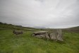
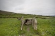
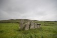
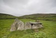
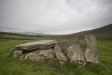
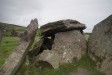
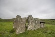
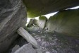
It doesn't matter that this is a smallish wedge tomb ... it's wonderful! The 2m x 1.5m gallery retains its roof and is blocked by two slabs, with the northern one purposely left short to provide access to the inside. In front of the gallery there is an open-topped portico/ante-chamber formed with 3 slabs on each side.
The construction was well executed. The slope of the gallery roof-slab is continued perfectly by the rising height of the portico stones, the tallest of which is 1.5m high.
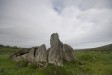
To the north, west and south hills rise up around the site, while to the east they extend over pasture to the bay and the mountains beyond. Both the monument's preservation and the location make this one of Ireland's little treasures.
At the time of my visit the field was occupied by a donkey. I wasn't sure how he'd take to me, but I approached anyway. He simply stood up and watched me go about my business. He did scare me half to death by braying in my ear at one point, but nothing more threatening than that. It's up to you if you want to risk the wrath of the wedge tomb guardian.
Click Thumbnail to View Full Size Image
_________
Like this monument
Marked Sites
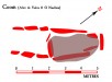
Site Plans
Click Thumbnail to View Full Size Image
 _
_Random Gazetteer
A Selection of Other Wedge Tombs
About Coordinates Displayed
|
This is an explanation of (and a bit of a disclaimer for) the coordinates I provide. Where a GPS figure is given this is the master for all other coordinates. According to my Garmin these are quite accurate. Where there is no GPS figure the 6 figure grid reference is master for the others. This may not be very accurate as it could have come from the OS maps and could have been read by eye. Consequently, all other cordinates are going to have inaccuracies. The calculation of Longitude and Latitude uses an algorithm that is not 100% accurate. The long/lat figures are used as a basis for calculating the UTM & ITM coordinates. Consequently, UTM & ITM coordinates are slightly out. UTM is a global coordinate system - Universal Transverse Mercator - that is at the core of the GPS system. ITM is the new coordinate system - Irish Transverse Mercator - that is more accurate and more GPS friendly than the Irish Grid Reference system. This will be used on the next generation of Irish OS maps. |


Page loaded from cache: (Generation time: January 18 2020 01:10:14.)