


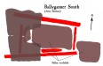
Ballyganner South : Wedge Tomb
Visit Notes
Sunday, 30th March 2003
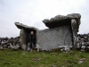
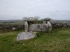
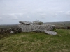
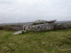
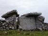
Knowing that this is the Burren's largest wedge tomb doesn't really prepare you for how BIG this tomb is! It's monstrously huge! The chamber is a great big 4.2m long by 3m wide. It was originally covered by a single slab, which because it overlaps the chamber walls by some amount would have been 5m long by nearly 4m wide.
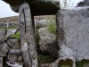
The front of the tomb is 1.7m high and the chamber slopes down to around 1m at the rear. The backstone is very well fitted between the two slabs that make up the walls. The west end of the tomb (the front), which is incorporated into a stone wall, is partially blocked by a massive slab, 'doorway' being left at the north end of this face. There is a low sill stone in the gap.
The majority of the roof lies within the chamber, but two pieces of the front section remain in situ, held up by a steel beam.
This tomb really is one of the wonders of the Megalithic World. Its scale is simply overwhelming.
Click Thumbnail to View Full Size Image
______
Like this monument
Marked Sites
Site Plans
Click Thumbnail to View Full Size Image
 _
_Old Images
Click Thumbnail to View Full Size Image
 _
_Random Gazetteer
A Selection of Other Wedge Tombs
About Coordinates Displayed
|
This is an explanation of (and a bit of a disclaimer for) the coordinates I provide. Where a GPS figure is given this is the master for all other coordinates. According to my Garmin these are quite accurate. Where there is no GPS figure the 6 figure grid reference is master for the others. This may not be very accurate as it could have come from the OS maps and could have been read by eye. Consequently, all other cordinates are going to have inaccuracies. The calculation of Longitude and Latitude uses an algorithm that is not 100% accurate. The long/lat figures are used as a basis for calculating the UTM & ITM coordinates. Consequently, UTM & ITM coordinates are slightly out. UTM is a global coordinate system - Universal Transverse Mercator - that is at the core of the GPS system. ITM is the new coordinate system - Irish Transverse Mercator - that is more accurate and more GPS friendly than the Irish Grid Reference system. This will be used on the next generation of Irish OS maps. |


Page loaded from cache: (Generation time: January 18 2020 01:11:40.)