


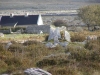
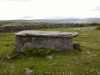
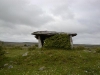
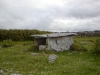
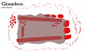
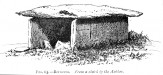
Gleninsheen : Wedge Tomb
Visit Notes
Saturday, 26th October 2002
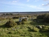
Just up the road from the more famous monument at Poulnabrone (County Clare) and only 5m from the road, but hidden behind quite a high wall, this box-like tomb is worth stopping off at. The farmer does not appear to appreciate people visiting it, which is probably due to idiots treasure hunting around here, for in the 1950s a beautiful gold necklace was discovered not far away.
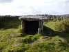
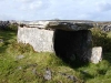
The gallery , aligned east-west and open at the east end, is 2m long and 1.3m square in vertical section. The roof, as with so many of these Burren style wedges is growing a fine crop of grass.
Sunday, 6th June 2004
Having driven past Poulnabrone (County Clare), knowing that it would be very busy, I decided to bring Uta to this lovely little tomb that no one ever seems to bother with. The gap in the wall has been blocked up, so that doesn't help!
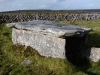
I was able to check out one of the other tombs nearby too, as well as spot the tomb at Berneens (County Clare) on the hillside above.
Like this monument
Marked Sites
Site Plans
Click Thumbnail to View Full Size Image
 _
_Old Images
Click Thumbnail to View Full Size Image
 _
_Random Gazetteer
A Selection of Other Wedge Tombs
About Coordinates Displayed
|
This is an explanation of (and a bit of a disclaimer for) the coordinates I provide. Where a GPS figure is given this is the master for all other coordinates. According to my Garmin these are quite accurate. Where there is no GPS figure the 6 figure grid reference is master for the others. This may not be very accurate as it could have come from the OS maps and could have been read by eye. Consequently, all other cordinates are going to have inaccuracies. The calculation of Longitude and Latitude uses an algorithm that is not 100% accurate. The long/lat figures are used as a basis for calculating the UTM & ITM coordinates. Consequently, UTM & ITM coordinates are slightly out. UTM is a global coordinate system - Universal Transverse Mercator - that is at the core of the GPS system. ITM is the new coordinate system - Irish Transverse Mercator - that is more accurate and more GPS friendly than the Irish Grid Reference system. This will be used on the next generation of Irish OS maps. |


Page loaded from cache: (Generation time: January 17 2020 21:39:21.)