


'The Mottee Stone' : Miscellaneous Site
Visit Notes
Sunday, 28th October 2001
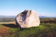
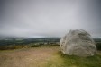
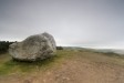
This not really a standing stone, but probably a relocated glacial erratic. It is however the single largest lump of quartzite you will ever see, measuring at least 3m in every dimension.
As you approach it from the car park, you can see what appears to be a steel handle protruding from the top. Why? When you reach the stone you are presented with a series of these steel loops up one side of the stone. Why? They are steps. When you climb them you can see a single cup mark in the top.
I need to find out more about this stone.

Sunday, 2nd September 2007
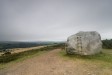
As I was so close to this oddity I decided to take another look. I also took the opportunity to tap out a tune on the metal steps. This is in a beatiful location. The stone sits on a rounded knoll with views to the Wicklow Mountains westwards and glimpses of the sea to the east.
The large car park is blocked off, so I imagine not many people come here anymore. The fact that it has a car park hints that this wasn't the case once. I can imagine lots of well-dressed people - women with parasols etc, down from the city - taking the air while visiting the curiosity that is The Mottee Stone.
To the east of the site there is a horrible scar on the landscape - a recent spoil heap from quarrying activity. I can't remember seeing this on my first visit.
Like this monument
Marked Sites
Miscellanea
Apparently the iron steps on this monster stone when struck in ascending order produce a full musical scale. I think this is more by luck than judgement though.
Random Gazetteer
A Selection of Other Miscellaneous Sites
About Coordinates Displayed
|
This is an explanation of (and a bit of a disclaimer for) the coordinates I provide. Where a GPS figure is given this is the master for all other coordinates. According to my Garmin these are quite accurate. Where there is no GPS figure the 6 figure grid reference is master for the others. This may not be very accurate as it could have come from the OS maps and could have been read by eye. Consequently, all other cordinates are going to have inaccuracies. The calculation of Longitude and Latitude uses an algorithm that is not 100% accurate. The long/lat figures are used as a basis for calculating the UTM & ITM coordinates. Consequently, UTM & ITM coordinates are slightly out. UTM is a global coordinate system - Universal Transverse Mercator - that is at the core of the GPS system. ITM is the new coordinate system - Irish Transverse Mercator - that is more accurate and more GPS friendly than the Irish Grid Reference system. This will be used on the next generation of Irish OS maps. |


Page loaded from cache: (Generation time: December 05 2019 23:16:30.)