


'Downpatrick Head I' : Barrow
Visit Notes
Saturday, 21st August 2010
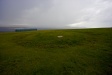
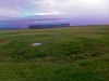
This is one of two low barrows on Downpatrick Head, a location that is very popular with walkers - I wonder how many realise these barrows are here.
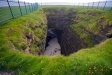
The barrow is defined by a shallow ditch and has a low raise mound about 10mm in diameter. Close by there is a large hole in the slope that opens out into a collapsed sea cave that is sensibly fenced in. This cave has a tragic history as the British used to throw people they didn't like into it. With the tide crashing in and nothing but high cliffs for miles along the coast anyone being thrown in would have certainly drowned. So, if you come to these barrows take a little time to reflect upon man's inhumanity at the cave-top.
Like this monument
Marked Sites
3D Anaglyph Images
Click Thumbnail to View Full Size Image
 _
_Random Gazetteer
A Selection of Other Barrows
About Coordinates Displayed
|
This is an explanation of (and a bit of a disclaimer for) the coordinates I provide. Where a GPS figure is given this is the master for all other coordinates. According to my Garmin these are quite accurate. Where there is no GPS figure the 6 figure grid reference is master for the others. This may not be very accurate as it could have come from the OS maps and could have been read by eye. Consequently, all other cordinates are going to have inaccuracies. The calculation of Longitude and Latitude uses an algorithm that is not 100% accurate. The long/lat figures are used as a basis for calculating the UTM & ITM coordinates. Consequently, UTM & ITM coordinates are slightly out. UTM is a global coordinate system - Universal Transverse Mercator - that is at the core of the GPS system. ITM is the new coordinate system - Irish Transverse Mercator - that is more accurate and more GPS friendly than the Irish Grid Reference system. This will be used on the next generation of Irish OS maps. |


Page loaded from cache: (Generation time: January 17 2020 21:32:16.)