


'Kilmashogue' : Wedge Tomb
This site has subsites
| Kilmashogue - Kilmashogue Hill - Standing Stone |
Visit Notes
Saturday, 8th September 2001
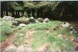
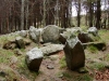
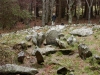
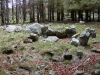
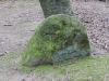
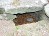
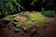
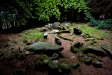
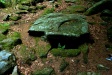
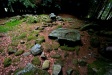
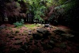
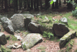
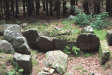
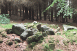
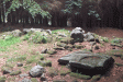
The cairn here is robbed out and flattened. Several kerb stones remain in place as does the floor of the cairn. The surrounding ditch and bank can still clearly be seen. The gallery walls are still evident and these are double lined, usually a style found in wedge tombs. The entrance to the rectangular chamber faces directly towards the mound at Montpelier (County Dublin).
The chamber appears to be no more than a widening of the passageway with the huge entrance stone is still in situ. This is a very peaceful and calming location. Despite being just 100m from a busy car park used by people setting off along the Wicklow Way any noise is cut out by the thick woods around it.
Saturday, 16th February 2002
When you park just 60m from a wedge tomb to go somewhere else how can you not pop in to take another look?
Just up the hill from the car park I wonder how many of the people from the 20 cars parked below either know that this tomb is here or bother to visit it.
In order to get some better photos I climbed a couple of trees today to enable me to look down on this lovely little tomb.
Thursday, 11th April 2002
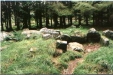
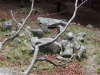
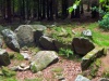
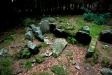
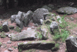
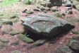
A great site to take people to. It is very easy to demonstrate the triple walling of this wedge and to show how later kist burials have been inserted into the cairn.
Click Thumbnail to View Full Size Image
_
Saturday, 20th July 2002
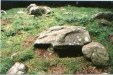
Anthony's first vist to this odd tomb. Without the one side stone of the chamber it is difficult to grasp the form. The kist burials to the rear of the chamber still make me smile. The one in particular is a very good example.
Sunday, 10th June 2012
I can't believe it's been so long since I visited this local tomb. It was one of the first sites I visited and it has a special place in my mind.
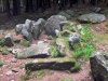
I can't add much more about this wedge tomb really, except to say that the trees have grown a lot and are cutting the light out especially on an overcast day like today. Hopefully, my photos turned out ok!
Click Thumbnail to View Full Size Image
________
Like this monument
Marked Sites
3D Anaglyph Images
Click Thumbnail to View Full Size Image
 _
_ _
_ _
_ _
_ _
_ _
_3D Animations
Click Thumbnail to View Full Size Image
 _
_ _
_ _
_ _
_ _
_ _
_Directions
From the R113 in south Dublin follow the signs for the Wicklow Way and park in the car park at O150 245. There are some steps in the car park that lead onto the track above. Directly above these steps there is a path leading up into the trees. This tomb is about 50m up this track.
Random Gazetteer
A Selection of Other Wedge Tombs
About Coordinates Displayed
|
This is an explanation of (and a bit of a disclaimer for) the coordinates I provide. Where a GPS figure is given this is the master for all other coordinates. According to my Garmin these are quite accurate. Where there is no GPS figure the 6 figure grid reference is master for the others. This may not be very accurate as it could have come from the OS maps and could have been read by eye. Consequently, all other cordinates are going to have inaccuracies. The calculation of Longitude and Latitude uses an algorithm that is not 100% accurate. The long/lat figures are used as a basis for calculating the UTM & ITM coordinates. Consequently, UTM & ITM coordinates are slightly out. UTM is a global coordinate system - Universal Transverse Mercator - that is at the core of the GPS system. ITM is the new coordinate system - Irish Transverse Mercator - that is more accurate and more GPS friendly than the Irish Grid Reference system. This will be used on the next generation of Irish OS maps. |


Page loaded from cache: (Generation time: January 17 2020 21:27:30.)