


'Leacanabuaile' : Stone Fort
Visit Notes
Monday, 10th August 2009
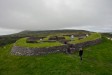
Like the nearby cashel in the same townland ( Cahergal (County Kerry)), this too has been restored. Although this is not as imposingly impressive as the other, I feel it is rather more interesting.
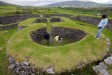
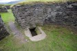
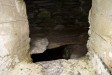
The walls are nowhere near as tall, but the huts inside the fort are more interesting, as is the presence of a souterrain , which leads from one of the huts to a chamber inside the wall. The original entrance to this souterrain is tiny and a new entrance has been created into the wall-chamber. The gate to this is unlocked, but very stiff. A headlamp would be needed to investigate the passage as no light gets in there. One of the slabs in the wall of the souterrain has carvings on it.
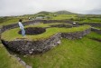
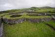
The internal structures nearly fill the central area. As you enter through the east-facing entrance you are confronted with the entrance into a rectangular structure. This building in turn leads into a circular hut. Either side of these two huts there are the walls of rectangular buildings that butt up to the wall.
There are some steps built into the walls, but these could be modern to provide access to the wall tops(?). They certainly aren't laid out the same way as those at Cahergal. There is a low ledge that runs around the inside of the cashel wall.
When you enter the fort you will notice a series of stepping stones that run from just inside the door to the rectangular building to the cashel entrance. This is actually a covered drainage system - quite sophisticated, really.
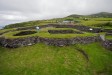
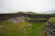
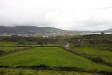
The views from the ramparts are impressive. You can see more of the approach to the site than you can at Cahergal. It would seem to me that this, much more defendable, site was used in less safe times and the occupants built and moved to Cahergal to be more impressive, rather than secure.
The security of this site comes from the wider views and the fact that the cashel crowns a very narrow rocky outcrop, with steep drops on two sides and pretty steep slopes on the other approaches. attacking this site would not have been easy.
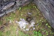
There is a large flag in the corner of the rectangular structure that has a depression in it. At first I thought this was a bullaun stone, but it seems to be too rough.
Click Thumbnail to View Full Size Image
____________
Like this monument
Marked Sites
Site Plans
Click Thumbnail to View Full Size Image
 _
_Random Gazetteer
A Selection of Other Stone Forts
About Coordinates Displayed
|
This is an explanation of (and a bit of a disclaimer for) the coordinates I provide. Where a GPS figure is given this is the master for all other coordinates. According to my Garmin these are quite accurate. Where there is no GPS figure the 6 figure grid reference is master for the others. This may not be very accurate as it could have come from the OS maps and could have been read by eye. Consequently, all other cordinates are going to have inaccuracies. The calculation of Longitude and Latitude uses an algorithm that is not 100% accurate. The long/lat figures are used as a basis for calculating the UTM & ITM coordinates. Consequently, UTM & ITM coordinates are slightly out. UTM is a global coordinate system - Universal Transverse Mercator - that is at the core of the GPS system. ITM is the new coordinate system - Irish Transverse Mercator - that is more accurate and more GPS friendly than the Irish Grid Reference system. This will be used on the next generation of Irish OS maps. |


Page loaded from cache: (Generation time: January 18 2020 01:10:27.)