


Cappaghkennedy : Wedge Tomb
Visit Notes
Sunday, 21st September 2008
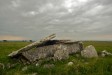
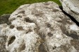
This really is a nasty tomb to reach, because it is on the top of a hill that is not only surrounded by ankle-breaking limestone pavements, but is also made of deeply fissured limestone. Please take great care when visiting this site.
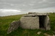
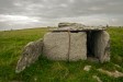
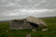
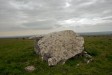
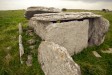
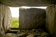
The tomb is, quite simply, wonderful. It is almost complete, retaining its massive roofstone, which has broken in two. The rear end of the roofstone has dropped back slightly and now points into the air. The walls are made from single slices of limestone, while the back is missing (hence, why the roofstone has tipped.)
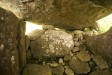
The front of the tomb is partially blocked by a slab that is 2/3 of the width of the tomb, leaving a doorway to one side. The interior is 1.6m tall and looks as if the floor was paved.
The views are wonderful from here and a lot of the wonderful geology of The Burren is visible. These views certainly make up for the effort it takes to reach the site, but the quality of the tomb itself does this on its own, anyway.
Click Thumbnail to View Full Size Image
__________
Like this monument
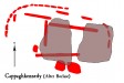
Marked Sites
Site Plans
Click Thumbnail to View Full Size Image
 _
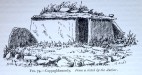
_Old Images
Click Thumbnail to View Full Size Image
 _
_Random Gazetteer
A Selection of Other Wedge Tombs
About Coordinates Displayed
|
This is an explanation of (and a bit of a disclaimer for) the coordinates I provide. Where a GPS figure is given this is the master for all other coordinates. According to my Garmin these are quite accurate. Where there is no GPS figure the 6 figure grid reference is master for the others. This may not be very accurate as it could have come from the OS maps and could have been read by eye. Consequently, all other cordinates are going to have inaccuracies. The calculation of Longitude and Latitude uses an algorithm that is not 100% accurate. The long/lat figures are used as a basis for calculating the UTM & ITM coordinates. Consequently, UTM & ITM coordinates are slightly out. UTM is a global coordinate system - Universal Transverse Mercator - that is at the core of the GPS system. ITM is the new coordinate system - Irish Transverse Mercator - that is more accurate and more GPS friendly than the Irish Grid Reference system. This will be used on the next generation of Irish OS maps. |


Page loaded from cache: (Generation time: January 17 2020 15:32:53.)