


'Greatheath I' : Barrow
This is a subsite of:
Visit Notes
Sunday, 17th February 2008
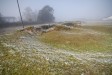
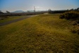
This is a wonderfully preserved little barrow. What's more it is right by the roadside and very easy to visit, which is a rarity. The central mound is a little over 1m tall and 5m in diameter. Around this there is a 1m wide fosse and an external bank that is also 1m high.
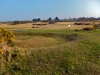
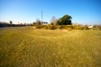
This is the most southerly of a group of barrows on Great Heath (in the townland of Greatheath) and the easiest to get to. The others are in gardens or on the nearby golf course. The unusual thing about this one is that it is located right next to a crossroad - which is why it's so easy to see.


Sunday, 11th April 2010
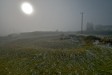
I simply could not resist stopping at this beautiful roadside barrow on the way back to the car. It's so easy to visit and, apart from a bit of encroaching gorse, it is in very good condition. It was also nice to take some pictures when I could see more than 20m!
Here, more than the other barrows, it is easier to appreciate the role the hills to the south play in this landscape.

Like this monument
Marked Sites
3D Anaglyph Images
Click Thumbnail to View Full Size Image
 _
_ _
_ _
_ _
_ _
_3D Animations
Click Thumbnail to View Full Size Image
 _
_Random Gazetteer
A Selection of Other Barrows
About Coordinates Displayed
|
This is an explanation of (and a bit of a disclaimer for) the coordinates I provide. Where a GPS figure is given this is the master for all other coordinates. According to my Garmin these are quite accurate. Where there is no GPS figure the 6 figure grid reference is master for the others. This may not be very accurate as it could have come from the OS maps and could have been read by eye. Consequently, all other cordinates are going to have inaccuracies. The calculation of Longitude and Latitude uses an algorithm that is not 100% accurate. The long/lat figures are used as a basis for calculating the UTM & ITM coordinates. Consequently, UTM & ITM coordinates are slightly out. UTM is a global coordinate system - Universal Transverse Mercator - that is at the core of the GPS system. ITM is the new coordinate system - Irish Transverse Mercator - that is more accurate and more GPS friendly than the Irish Grid Reference system. This will be used on the next generation of Irish OS maps. |


Page loaded from cache: (Generation time: January 18 2020 01:10:17.)