


Coolbeg : Wedge Tomb
Visit Notes
Sunday, 17th August 2003
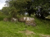
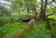
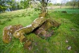
This is a lovely riverside wedge tomb , which sadly has its views of the river blocked by a wall of large trees. Its gallery is 7m long with good, but not complete, double walling along both sides. One roofstone is roughly in place at rear and may have cup marks on its upper surface.
At the front of the tomb some of the facade stones are present and a fallen lintel/roofstone blocks the entrance.
The middle 1/3 of the gallery filled with rubble and some of the covering cairn remains on the north side to the height of the side stones.

Monday, 25th April 2011
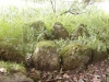
You know, I'd been saying to Tatjana that I'd never been here, and when I got here with her I didn't recognize it at all. Looking at my old pictures I can see why! It was so overgrown 8 years ago when I first visited.
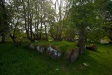
This time the site was very clear. The exquisite double walling down the north side was fully visible. It was easy to make out all the side stones, the façade and the portico. This is a wonderful monument and better access ought to be available!
Click Thumbnail to View Full Size Image
________


Like this monument
Marked Sites
Random Gazetteer
A Selection of Other Wedge Tombs
About Coordinates Displayed
|
This is an explanation of (and a bit of a disclaimer for) the coordinates I provide. Where a GPS figure is given this is the master for all other coordinates. According to my Garmin these are quite accurate. Where there is no GPS figure the 6 figure grid reference is master for the others. This may not be very accurate as it could have come from the OS maps and could have been read by eye. Consequently, all other cordinates are going to have inaccuracies. The calculation of Longitude and Latitude uses an algorithm that is not 100% accurate. The long/lat figures are used as a basis for calculating the UTM & ITM coordinates. Consequently, UTM & ITM coordinates are slightly out. UTM is a global coordinate system - Universal Transverse Mercator - that is at the core of the GPS system. ITM is the new coordinate system - Irish Transverse Mercator - that is more accurate and more GPS friendly than the Irish Grid Reference system. This will be used on the next generation of Irish OS maps. |


Page loaded from cache: (Generation time: January 18 2020 01:10:06.)