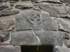
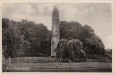
Antrim : Round Tower

CountyAntrim
Grid RefJ 154 877
Longitude6° 12' 31.36" W
Latitude54° 43' 26.38" N
ITM east480366
ITM north584435
Nearest TownAntrim (1.2 Km)
OS Sheet14
UTM zone29U
UTM x449041
UTM y5761192
Large Image

Antrim Round Tower ::

Postcard sent in 1926.

Images

Click Thumbnail to View Full Size Image

Saturday, 27th July 2002

Click To View Large Image_Click To View Large Image_Click To View Large Image_Click To View Large Image_

Old Images

Click Thumbnail to View Full Size Image

<a href='/show/image/9471/antrim.htm' class='redlink'>Permanent Link</a>_<a href='/show/image/9501/antrim.htm' class='redlink'>Permanent Link</a>_<a href='/show/image/9502/antrim.htm' class='redlink'>Permanent Link</a>_<a href='/show/image/9725/antrim.htm' class='redlink'>Permanent Link</a>_

Random Gazetteer

Valid CSS Valid HTML
Page loaded from cache: (Generation time: January 18 2020 01:11:56.)
Top of page | Feedback | About this site
© Copyright Tom FourWinds 2001-2020