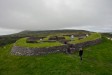
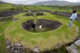
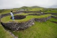
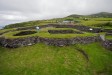
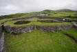
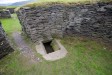
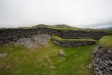
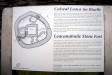
'Leacanabuaile' : Stone Fort

TownlandKimego West
CountyKerry
Grid RefV 446 808
GPSV 44563 80818 (3m)
Longitude10° 15' 41.44" W
Latitude51° 57' 28.21" N
ITM east480366
ITM north584435
Nearest TownCahershiveen (2.7 Km)
OS Sheet83
UTM zone29U
UTM x449041
UTM y5761192
Large Image

Leacanabuaile Stone Fort ::

After O Riordain & Foy

Images

Click Thumbnail to View Full Size Image

Monday, 10th August 2009

Click To View Large Image_Click To View Large Image_Click To View Large Image_Click To View Large Image_Click To View Large Image_Click To View Large Image_Click To View Large Image_Click To View Large Image_Click To View Large Image_Click To View Large Image_Click To View Large Image_Click To View Large Image_

Site Plans

Click Thumbnail to View Full Size Image

<a href='/show/image/9019/leacanabuaile.htm' class='redlink'>Permanent Link</a>_

Random Gazetteer

Valid CSS Valid HTML
Page loaded from cache: (Generation time: January 18 2020 01:13:07.)
Top of page | Feedback | About this site
© Copyright Tom FourWinds 2001-2020