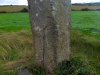
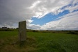
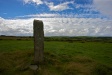
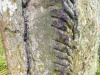
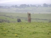
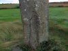
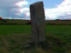
Breastagh : Ogham Stone

CountyMayo
Grid RefG 183 338
GPSG 18314 33802 (7m)
Longitude9° 15' 11.67" W
Latitude54° 14' 47.3" N
ITM east480366
ITM north584435
Nearest TownKillala (4.3 Km)
OS Sheet24
UTM zone29U
UTM x449041
UTM y5761192
Large Image

Breastagh Ogham Stone ::

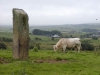
You can see where the cattle use the stone for rubbing against. Perhaps a fence is needed to protect what is left of the script (placed at a suitable distance obviously).

Photo Taken: Sunday, 4th August 2002


  Image 11 of 11  
             

Images

Click Thumbnail to View Full Size Image

Saturday, 21st August 2010

Click To View Large Image_Click To View Large Image_Click To View Large Image_Click To View Large Image_Click To View Large Image_Click To View Large Image_

Monday, 25th October 2004

Click To View Large Image_Click To View Large Image_

Sunday, 4th August 2002

Click To View Large Image_Click To View Large Image_Click To View Large Image_

3D Anaglyph Images

Click Thumbnail to View Full Size Image

<a href='/show/image/10444/breastagh.htm' class='redlink'>Permanent Link</a>_<a href='/show/image/10445/breastagh.htm' class='redlink'>Permanent Link</a>_

Old Images

Click Thumbnail to View Full Size Image

<a href='/show/image/4450/breastagh.htm' class='redlink'>Permanent Link</a>_

Random Gazetteer

Valid CSS Valid HTML
Page loaded from cache: (Generation time: December 05 2019 05:35:23.)
Top of page | Feedback | About this site
© Copyright Tom FourWinds 2001-2019